资料下载

×
level set方法的雷达图像跟踪
消耗积分:5 |
格式:rar |
大小:1.11 MB |
2011-03-07
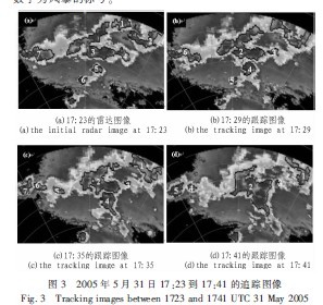
对多普勒雷达图像中的风暴进行准确的识别和跟踪,是下一步进行天气预报的前提。目前雷达图像的主要跟踪方法是进行相邻时刻图像中风暴的匹配,这些匹配方法会产生一定的误差,特别是在风暴分裂与合并的时候。基于这一问题,将一种改进的level set方法用于雷达图像中风暴的跟踪。首先在第一幅雷达图像中识别出风暴的初始轮廓,利用改进的算法,即不断交换轮廓内链和外链的格点,将初始轮廓不断演化确定出第二幅图像中风暴的轮廓,依此再跟踪下一时刻的风暴。由于轮廓的演化是基于格点的,所以在风暴发生分裂或合并时,可以实现轮廓的准确跟踪,进而为灾害性天气的预警工作打下良好的基础。
- Abstract:
- The accurate identification and tracking of storms based on Doppler radar images is the premise of weather forecast. At present, the main tracking method of radar image is matching storms between adjacent images, which can cause some errors, especially at the time of storms splitting and merging. Based on this problem, an improved level set method is used to track storms in the radar image. Initial contours of storms in the first radar image were identified, and contours of storms in the second image were the evolution of initial contours, which was achieved by the improved level set method, i.e. switching elements between the inside lists and outside lists of contours, and so were the next radar images. As the evolution of contours is based on the grid, the accurate tracking of contours can be achieved at the time of storms splitting and merging, and finally this improved method can build a good foundation for the early warning of severe weather.

声明:本文内容及配图由入驻作者撰写或者入驻合作网站授权转载。文章观点仅代表作者本人,不代表电子发烧友网立场。文章及其配图仅供工程师学习之用,如有内容侵权或者其他违规问题,请联系本站处理。 举报投诉
评论(0)
发评论
- 相关下载
- 相关文章


